


Section 26-2: Final Day of the Triple Crown (10 photos, 4 videos)

Section 26-1: Hachita Ghost Town, Endless Arid Desert, and Jet Fighters (19 photos, 3 videos)

As I came around the base of a hill, I could see the structures on top of a small ridge. Before I reached them I stumbled across a vertical mine shaft, with no barrier, cover, or rope to warn people (or cattle) of this sudden 40 foot hole in the ground. I tossed a rock down and it was deep. I passed a few more of these surprise pits and thought how insanely dangerous it would be to night hike this area.
Section 25: Slackpacks, An Emergency Blizzard Bail Out, and a Thanksgiving Feast in a Concrete Dome (20 photos, 1 video)

We began to discuss contingency plans because we were both getting dangerously cold and we very soon realized we had to bail. Hyperthermia was right around the corner. The trail crossed Highway 90 in about another mile and we prayed that cars would be passing by in this storm. When we arrived, our hands were so numb that operating the latch on the cow gate next to the road became a two man operation. My fingers were frozen in place and I could barely stick my thumb up for a hitchhiker signal.
Section 24-3: Gila Cliff Dwellings, Hikers Reunited, and The Tree of Soles, (25 photos, 3 videos)

The road walk flew by and when we arrived at the famous CDT outpost, Nightwatch and Snow White were there waiting! This duo I met in Glacier National Park on my SECOND NIGHT on trail, when we were roommates at an assigned campsite. I hadn’t seen them since. Another hiker, Sunny, from Tokyo, was there and we couldn’t believe that all of us had met up to form the last SOBO bubble of the year.
Section 24-2: The Gila Alternate, Endless Canyon Walls, Spires, and a Much Needed Hot Spring (24 photos, 4 videos)

It was grey out again and we hoped the sun would return to warm up the river crossings and allow us to dry out as much as possible. The massive spires, rock walls, and crazy formations continued and I hiked in total awe for most of the day. We saw a wild boar with her piglets as we kept trekking along. I frequently fell behind because I stopped to take photos at every single turn in the canyon. It was all so unbelievably beautiful, even in the soggy weather.
Section 24-1: Ranches, Sunsets, Bulldozers, and Bacon (22 photos, 1 video)

I walked about two hundred meters into the woods to look at a small lake I noticed on my maps. Then I saw a cow carcass that was fresh. It was gruesome. It was new. It was what the coyotes were feasting on the night before as they howled and caused all that noise. Very close to where we were sleeping.
Section 23: Neat Rocks, Lava Fields, and Perfect Sunsets En-Route to Pie Town (23 photos, 2 videos)

Then, just a couple miles from town, a zany character named Jeremy rolled up on a 4-wheeler with a guitar case strapped on the back. He said he loves chilling with the hikers when they get to Pie Town but there hasn’t been any come through in awhile now. He added that he would stop by the Toaster House with beer and bacon for breakfast and we parted ways.
Section 22: Breathtaking Desert Scenery, Mount Tsoodził, and Prison (27 photos, 1 video)

Section 21: Ghost Ranch, Stunning Desert Scenery, and Sleeping in a Bus (21 photos, 2 video)

I made it to camp right at nightfall and laughed at myself as I set up the tent, I had forgotten the streamlined process and made some near-rookie mistakes. However, I was confident that I made the right decision to switch from my hammock to the tent for the remainder of New Mexico, with its long long stretches of treeless, flat, desert.
Section 20: Winter Ain't Coming, It's Here (21 photos, 4 videos)

Intermission #2
I froze my butt off trying to land a hitch to Denver, to then catch a flight to Austin, but nobody was pulling over. So after three hours I called it quits, bought a bus ticket, and had a terrible Greyhound experience. Everyone seemed to be coughing and sneezing, and at every rest stop at least 80% of the passengers departed to have a cigarette.
THE 50-MILE DAY: Yup, I hiked 50 miles in a Single Day (17 photos, 2 videos)

Not long after I caught a glimpse of the outskirts of Rawlins and saw it get swallowed by a white wall of snow pouring down down the clouds. The winds shifted to hit me head on and the snow that it brought was very wet, clinging to my beard and soaking through my rain jacket. I was running on empty but less than five miles remained between me and town.
Section 19: RV's, Ice, More Aspens, and Sleeping on State Lines (21 photos, 2 videos)

As I was sitting in my hammock and eating breakfast, I heard some rustling behind me from the creek. I turned and saw a huge bull moose pop out of the brush and we startled each other. He was no more than 20 feet from me and I saw his eyes widen in surprise. If this was a cartoon, and he was wearing a hat, it would have jumped up off of his head in typical Looney Toons fashion. He bolted back into the brush before I could reach for my camera or bear mace.
Section 18: Summits, Moose, Views, and Training for the 50-Mile Day (22 photos, 2 videos)
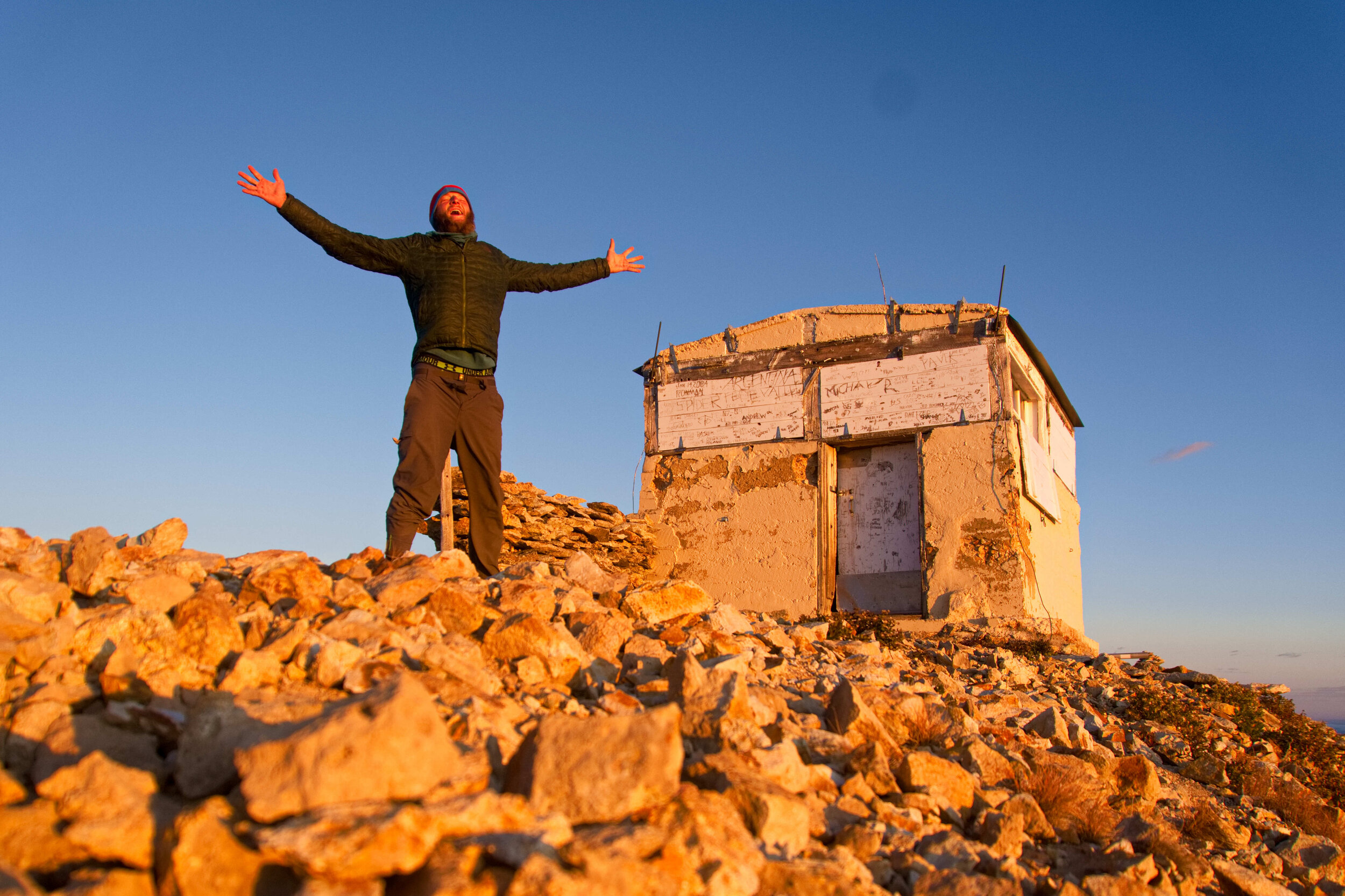
I then continually had to lean into the currents and was almost knocked off my feet a couple times. The sun had set by the time I reached the summit and I was surprised to find a crude stone shelter perched on top. I inspected it carefully and found it was sealed up pretty tight, no wind was drafting in, but there was evidence of marmots. It was dark out and a full 2.7 miles of exposed and windy ridge-walking to reach tree cover, with possibly more to find suitable hammock trees, and I was just too exhausted to do that.
Section 17: Snow, Rain, Cold, Alt Routes, and an Abandoned Radio Tower (25 photos, 2 videos)

I reached the top of the ridge and saw some storm clouds heading my way. Crap. It eventually caught up with me as I hit Jones Pass and some light flurries filled the sky. I was enjoying the scene for a bit until booming thunder joined to party. There was an alt route from Jones Pass that dipped down to Clear Creek but I was already a good bit beyond that junction so I decided to push forward. It was a scary and intense mile before the thunder subsided as I began to descend off of the exposed ridge.
Section 16-2: Mountain Goats, Factory Ruins, and Two 14-ers in a Day (15 photos, 2 videos)

The final push to the top was steep and exhausting and being above 14,000 feet certainly did not help. A mountain goat was sitting next to the trail and stared at me as I went by, like he was the gatekeeper to the final level. I had the 14,278 tall Grey’s Peak all to myself when I arrived. I took a celebratory shot of Breckenridge whiskey that I packed out and enjoyed the endless views for quite a while.
Section 16-1: MOOSE, Crazy Ridgelines, Cabins, and Trail Towns (26 photos, 3 videos)

We got lunch at Mountain High Pies which was some of the best pizza I’ve ever had and then Neil drove me back to the trail in the afternoon. I walked past Camp Hale where the 10th Mountain Division trained for WWII and the trail went by right by some old barracks which was like walking through history. The gloomy sky added to the ambiance and it was kind of a creepy feeling.
Section 15-2: The Changing Aspens, Alt Routes, Blue Skies, and Tall Passes (24 photos, 2 videos)

It was a little warmer than usual this morning and the trail was gentle and cruisey so I racked up some miles right off the bat. I soon reached Route 209 which was newly paved this summer after some nearby avalanches completely wiped out sections of the road. I then began the long climb up Lake Ann Pass, about 3,000 ft over 8 miles.
